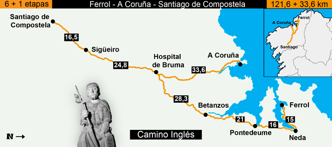
The Camino Ingles is the shortest of the Caminos at 120km from Ferrol on the Coast (where ships of Pilgrims mainly from England, hence this Way's name, but also from Scandinavia would land).

Guidebooks:

Image taken from http://www.pilgrimagetraveler.com/camino-ingles.html
The route heads essentially South around the Ferrol bay before heading to Pontedeume, Betanzos, Bruma and Segueiro passing through some beautiful countryside on the way - a lot of the eucalyptus forests that walkers of the Frances route from Sarria will be familiar with but this way is more difficult with longer stages (due to little choice with accommodation) and a lot of hills.
The starting point's Waymarker in Ferrol
Guidebooks:
- The CSJ has a guidebook on the Camino Ingles for £5 (see http://www.csj.org.uk/product/the-camino-ingles/) or the 2014 edition is available as a free download (although consider giving them a donation on their website) at http://www.csj.org.uk/wp-content/uploads/2011/07/Camino-Ingles-Master-PDF-Sept-2014.pdf
- Cicerone guides publish a book on the Northern Caminos which includes the Ingles for £16.95 (http://www.cicerone.co.uk/9781852847944.cfm#.VrSTVWfcuUk) - I used this guide and just scanned in the relevant pages before printing them out and taking them otherwise the book is rather heavy for only a few pages of information or you can just download the Ingles section of the guide for £3.56 (look on the 'buy individual routes' section of the page).
Whilst looking to see if anyone else produced a guidebook I came across this information on the American Pilgrims on the Camino's website (http://americanpilgrims.com/camino/route_descriptions/route_ingles.html):
'In December 1779, the leaking ship carrying John Adams and his companions to Paris was forced to put in at Ferrol from where they eventually made their way by land. Adams wrote about the Camino in his journal and he remarked there that he "…always regretted that We could not find time to make a Pilgrimage to Saint Iago de Compostella."'
| |

Comments
Post a Comment